Search the Community
Showing results for tags 'surveying'.
Found 4 results
-

Creating a surface model in Civil 3D from existing 3D polylines, lines and points
0misclose posted a topic in Civil 3D & LDD
Hi all, I'm quite new to Civil 3D and I've tried to have a look online to find what I'm looking for but I feel it might be easier to just ask. I'm wanting to generate a surface model of a complex feature survey which I currently have in AutoCad. All the 3D linework for kerbs, retaining walls, footpaths etc. as well as spot heights are already in the AutoCad file (due to the nature of the project the workflow isn't very nice and predominantly involves DXFs which are then stitched into the main file and the layers are adjusted afterwards). I don't have any codes or data input workflows setup within Civil 3D. I have another survey software package that I normally use to generate my surface models but it will be very time consuming to import the DWG and set it up beforehand due to the scale and amount of breaklines so I was curious if it would be easier for me to try and do it in Civil 3D (it might not). How easy is it to take 3D polylines, splines, lines and points from a DWG and generate a surface in Civil 3D? Is it possible to select all the lines and ensure they are breaklines? Are you able to make select layers non-contourable? How easy is it to generate model boundaries? I would greatly appreciate any guidance. Regards, Ryan -
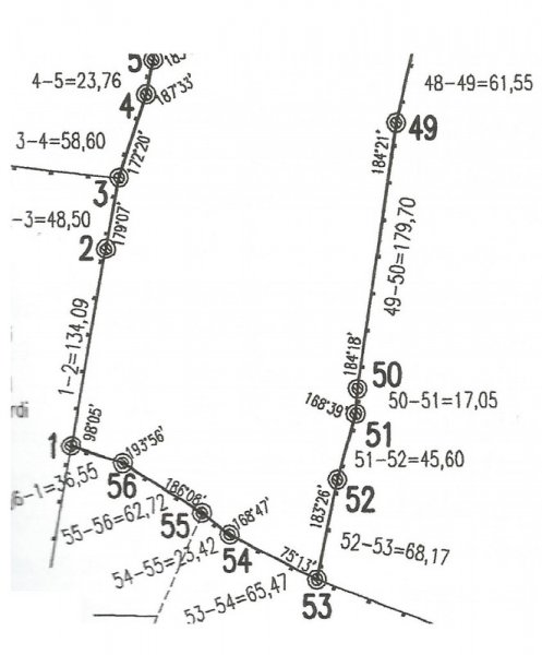
 Hi everybody, I've been reading tutorials about entering surveyor data, but still there is something I don't get it. Let's say I want to draw this scan in autocad (I already know how to enter relative xy/polar coordinates). I guess I should start the polyline at point named 1 and then enter @134.09 Segment 1-2 is visible less than 90º north, but even if I draw a visual aproximation angle for 1-2 to start de drawing, how would I then add the second segment 2-3 with the new bearing respect 1-2? How would I get a true to scan polygone? I will be gratefull of there is any explanation/example. Thanks. Paul
-

Insert circles at each corner/intersection. Need help.
general marko posted a topic in AutoLISP, Visual LISP & DCL
can someone help me with a lisp routine that inserts circles at every intersection of a polyline/series of line including its endpoint. thank you very much in advance. -
Hi I used to have a lisp that gives me a delta in one click from measured point to design point. It showed me deltas in x,y,z with an arrow pointing towards the theoretical point. If anyone has seen this lisp or would be willing to write me one that would be great! I use this in dimensional metrology. I have a program from New River Kinematics that can do analysis but if there is adjustment to be done often client does not understand the analysis and I have to draw dim in Acad or worst case to PDF... That takes too much time. Also I am missing a lisp that can do least square adjustment with point weighting. I was doing another field of work for six years and now some of my tools are missing...