Search the Community
Showing results for tags 'survey'.
Found 12 results
-

Block showing distance with arrow pointing in correct direction?
Akeane posted a topic in AutoLISP, Visual LISP & DCL
So the problem im having is i have code that runs to show the offset of measured points to design points, unfortunately the code works by inserting one of 4 predefined blocks for NSEW, or one of 4 when in 2 directions; only showing orthogonal distances. These work by passing through the distance to... -

triangles by three sides - for irregular houses surveying
harinezumi posted a topic in AutoLISP, Visual LISP & DCL
This routine helps me to draw surveys of irregular spaces, with triangles (sides and diagonals). It asks for the measures of the three sides, insertion, lying and direction (clockwise/counterclockwise). Do you have any idea to make it better? I would love for example to be able to see the ghost... -
I am having a hard time converting a .las file to create a surface in C3D & I was wondering if anyone had familiarity with this. I brought the .las file into ArcGIS and created a Raster then extracted contours from the raster but this did not work out the way I hoped. I see that C3D is able to open...
-

Possible to give a node a Z value from text?
Clifford169 posted a topic in AutoLISP, Visual LISP & DCL
Long timer user first time poster. I have an old survey that we don't have the raw data for anymore. There are levels associated (in text form) to the nodes we have created from LSS, however the nodes themselves are all 2D. Is there a way to tell those nodes to shift their Z value to the he... -
I've incorporated and created many LISP functions for surveying purposes in AutoCAD. I've been wanting to share them, so here goes. A lot of the functions reference other functions. I've used the naming scheme: mfcb* for My Functions CBass (me) mfcbLM for My Functions Lee Mac (because he is aw...
-
I just have normal autocad 2016, nothing fancy like civil 3d. I was wondering, is there a way i can bring in a survey point data file (.txt or .asc) into Autocad. Maybe by something in program by default, or a 3rd party plug in that is compatible with autocad. I don't want to spend way more money fo...
-
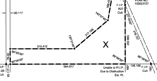
Hi Everyone, Just wondering if anyone knows of a good lsp routine for doing the following, or if anyone knows how to do this with built in capabilities in AutoCAD 2015. Basically I want to annotate angles and distance for survey drafting so I can produce plans that look like this plan that I've...

-
Hi Everyone, I have to survey and draw up a set of plans for a building that has a number of walls out of square. What's the best way to do that these days. Anticipated answer 1: "I choose a wall to act as the Datum x and Y axis and then run my measurements off these." Anticipated answer...
-
I am looking for a way to import my regular p,n,e,z,d text files with a custom tag for the point number. For example when I collect OG shots I like to number them OG##(
-
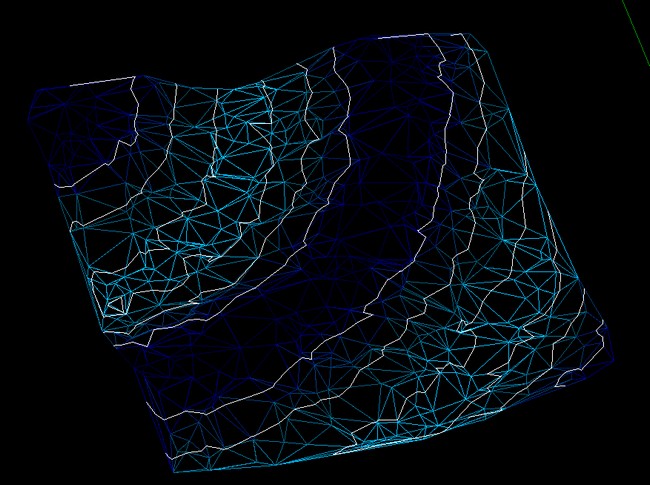
I found an interesting routine that allows coloring 3Dfaces a survey, according to altitude. By chance, someone knows a similar routine but which takes into account the contours/curves? (See image with the results of routine indicated)
-
 I have a drawing of a factory, with different equipment foundations laid out. I'm trying to do a type of surveying, get a distance and angle measurement from a specific set point in the drawing. So far i've only been able to use the Aligned Dimension function to show the distance between the se...