Search the Community
Showing results for tags 'site plan'.
Found 6 results
-
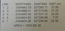
 I have details as below Line Northing Easting Distance 1 2 2554942.79 527285.17 37 metrer 2 3 2554966.41 527313.65 27.37 meter . . . . 5 1 ............. How to draw these lines please explain.
-
Hi everyone. I am looking for some help / advice / tutorial links etc. I am trying to get a site layout (roads, footpaths, buildings, open space) from Auto CAD into 3DS Max. I am quite new to Max, i know how to import and scale my drawing, and i know how some of the modifier tools work, but...
-

Need help with creating Site Plan from Deed Page
rodjos1000 posted a topic in AutoCAD 2D Drafting, Object Properties & Interface
Hello All, Having a hard time figuring best way to plot this deed. The many radiii are throwing me off and I end up with a triangle. Any help or tutorial would be greatly appreciated. Just need to unlock the first steps. I have done simple plans before, but this one is above my expertise. He... -
Here's an odd one (hi everyone!), a planning consultant has asked me to show the roof pitches on a site plan, and I'm stumped. Any ideas? This is what I've done so far: Sorry to bother, any suggestions welcome! I'm so far thinking of showing a few basic cross sections on the same drawin...
-
Hi, I received a site plan for my house in an unknown scale. It is in 1'=100' scale printed on 24x36, but for some reason I cannot work with it in AutoCAD 2009. I'm trying to place my 1'=30' scale house on the site plan, but the house is ending up gigantic and not to scale. TutorCAD.dwg
-

How to import .txt file with .dwg site plan to generate contours
littlerach posted a topic in AutoCAD General
Hi All, As a preface... I'm new here. Now here is my question: a civil engineer sent us a .dwg file for a site survey. However, the .dwg contours are just showing up as a series of overlapping rectangles. He attached two .txt files, one for elevation point locations, the other for tree locat...