Search the Community
Showing results for tags 'raster image'.
Found 10 results
-

How to correctly scale a raster image attached into an exiting file?
sinergy2020 posted a topic in AutoCAD 2D Drafting, Object Properties & Interface
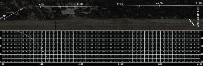
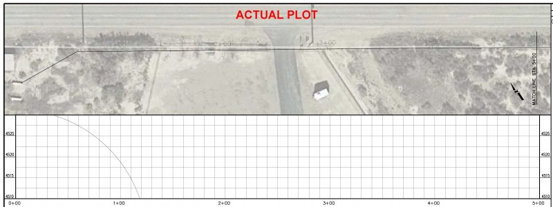
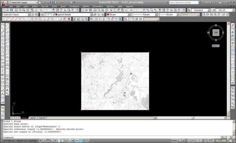
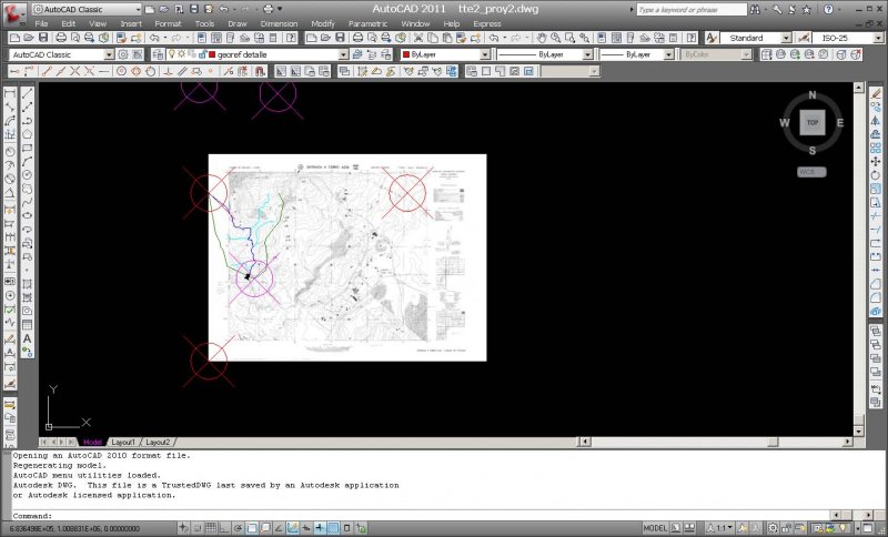
Hi I am trying to insert a raster image (aerial photo from google maps) in an existing topo map in .dwg format (am using autocad 2019 architecture) I use the usual procedure: https://www.cadtutor.net/tutorials/autocad/scaling-images.php The image gets scaled but can't see any longer the existing object (the pre-existing topo map on which this raster I wanted to scale to) Zoom extents only shows the scaled image. What may be happening? or what command should I use in order for the two images to be seen at the same time and be overlapped (initial intention)? Please have a look at the attached file after the insertion and scaling of the raster. Any help appreciated 4442-FINCA TORRADES AVINYO-autocad-arch.dwg -
I have a set of aerial images that I am hoping to use as a basemap for a paving project; about 20 images in total. Each is in TIFF format with an associated .tfw file. When using MAPIINSERT to place these images, only about six of them locate in the correct place. I can tell because I am placing them along with some GIS map linework. The remaining images place correctly relative to eachother, but very far from where they ought to be. I have tried placing them with other "Units for Insertion Point and Density," but it does not solve my problem. Could it be that they are somehow referencing a different coordinate system? My drawing is set to use HARN Oregon State Planes, North Zone, International Foot. I'm not sure how to view the info contained in the .tfw to see if there is something different about each of them. Perhaps if I could do that, I would be able to sort this out. Any help is appreciated!
-

Raster Image looks out of place but isn't
hcostanzo posted a topic in AutoCAD Drawing Management & Output
Hello! I'm hoping someone knows a fix for this. I'm working on a large project, and I have 14000 feet of plan & profiles split into 500 ft sections, with a raster image as the background of all the plan views. The plan viewports are rotated 36 degrees using mvsetup. The problem is that when I go to any of the layout tabs to view my sheet the raster image appears to have shifted over, but when I plot the sheet the raster is in the correct spot and everything looks good. I would like to work within the layouts, but can't when the images appears out of place. Sorry for the long explanation, I just wanted to cover as much of the problem as I could. Any help is greatly appreciated, and thank you in advance!
-
Hello, well i need your help for a college project.. i have a map from an abandoned camp in the suburbs of the city and i have to make a 'digitization' (maybe through Raster Image??!!) into AutoCAD (im working on Autocad 08) ... Can someone help me and write some kind "directions" on how to do this?! Thanks in advance!
-

AutoCAD loads an image that doesn't exist anymore
jdavid10 posted a topic in AutoCAD Drawing Management & Output
In my drawing, I inserted a raster image file. I converted it into a block so I can modify it and I scaled it like this: I saved my drawing and I close AutoCAD, but when I open AutoCAD again the image shown on the drawing file is not the same image that I had inserted previously. The image shown is one that I had inserted before the first one but I had erased it from the file because I had to crop it in photoshop to reinsert it again. I used the purge command to purge the block, I used the image command and i detached the image. But the image says "unreferenced" when I do the "image command" even though it has the right location and folder. I don't know what to do anymore. Please help
-

Raster Image later displays as the file name only
darrellk-1 posted a topic in AutoCAD 2D Drafting, Object Properties & Interface
Running AutoCAD 2004, XP Pro I have inserted our company logo into the title block as a Raster image. The logo is png, and I have tried retaining the path and not retaining the path with the same result. After saving this as a template, I reopen as new sheet to start a drawing and the logo is now the path name. I have erased and reinserted the logo countless times and sometimes it sticks, other times not so much. Help! -

Raster Image moves in Paperspace when zooming/ Plotting
ljhignett posted a topic in AutoCAD Beginners' Area
Hi, As the title suggests i am having troubles plotting out of paper space. In my drawing i have an aerial photograph (inserted as a raster image) that has been scaled, rotated and shifted onto the relevant co-ordinate system. I have a locked viewport and when i zoom in or out the photo 'jumps' around in a random fashion, same when i hit plot preview it appears out of place. I was wondering what could be causing this because i thought that paper space was simply 'viewing' whatever was in model space not being physically able to shift objects. Any help would be greatly appreciated Cheers Logan -
Hi, I have some issues with Raster Image lately when I wanted a scanned jpeg of 210 x 297 mm (a4 dimension) that I want to fit into a 180x220 mm rectangular box in Autocad. I have used Photoshop CS 3 to change the image size to 180x220. However when I insert the Raster Image files, some files are automatically set to 180x220 (as expected) and others are scaled down and I have to re-scale them (reset the scale value to 1, change the x-value and the y-value is automatically changed, but on the overall it is 180x220, sometimes x is more than y or sometimes y is more than x, but within 1-3 mm) I want to know : 1. What is the best principle or techniques of knowing/changing image dimension (mm) 2. How to be able to scale raster image in x-axis and y-axis independently of one another? 3. Remove white background to neutral background? Thank you in advanced, Regards, Nicolas.
-

Plot problem - a COPY of raster seems to jump to front during plot, then disappears?!
Tallguy posted a topic in Map 3D
Hi CADTutors, this is an odd one. I'm plotting polylines, SHP data and a background raster. Until yesterday, all was well. Today, odd things are a-happenin'. This is a screenshot of the sort of thing I want to plot: The purple areas are CONNECTED and STYLED (in Display Manager) shp data, the black/white/blue/green lines are polylines, the raster background (GB Ordnance Survey Miniscale tile) is STYLED in Display Manager as Raster>>>33pc fade. When I plot to jpg, I get the same selected area of print, but just the OS tile UNfaded and nothing else. When I plot to PDF, and i open the PDF, I can watch the PDF "build" itself and the correct data is there (as per the screenshot) BUT it then gets "covered up" by the OS tile, unfaded. From this, I surmise that it's plotting everything correctly BUT then putting a copy of the UNfaded Raster tile ON TOP of everything, obscuring it. . I only know this 'cos the PDF build-up shows me what it's doing. It didn't do this until yesterday, and this has happened before but "it just sort of came back". I tried the following today, no luck: All the various "send to back" options for the raster >> wouldn't explain the un-fading. WBLOCK out the polyline data, create a new DWG, INSERT block, re-import the raster and re-connect and STYLE the SHP file. Restart my machine and do all of the above. Restart my machine and not run any other applications (Outlook, Internet Explorer etc). Hit the monitor with a binder until it bleeds liquid crystal, and otherwise act like a child having a tantrum . That was satisfying but ultimately unproductiveo:). What's most annoying, apart from all the annoying stuff, is I can see it's gonna happen. During the plot process (I love watching a little progress bar fill up from left to right), I see my display turn white, then this un-faded raster fills the screen, plot completes, the un-faded raster disappears and leaves my screen as per the screenshot. I check the plot and hey presto! it's screwed. In effect, I think it's laughing at me. Dear, dear AutoCADists, please could you help? Or, failing that, could you just send me money to soothe me? Pounds Sterling is fine, as is U$D or €Euros...
-

Inserting Raster Image JPEG into AutoCAD...looks pixilated.
Pablo posted a topic in AutoCAD Drawing Management & Output
I'm trying to insert a JPEG of a SketchUP model as a raster image into paper space. The JPEG looks really tight and clear when viewing on its own but when I insert it into AutoCAD it looks pixilated and slightly distorted in places. Driving me crazy...any advice?