Search the Community
Showing results for tags 'point'.
-
Changing / Converting Points into Blocks / Objects
highguyuk posted a topic in AutoLISP, Visual LISP & DCL
Long time lurker and user of the site. Apologies my first post is a question rather than an answer but now I’ve made the leap of faith who knows the possibilities! I have a drawing with approx. 50 points in it. These points have been created from exporting a file from our MapInfo software into CAD format. Each of these points represents a feature (although everything contained within the drawing is just 1 feature) and I need to be able to attached a symbol (and then associated key) to define the feature when I xref in other similar drawings. I hope I described that ok. After some searching, I’m led to believe I need to use an LSP command/file/code etc.? I have no knowledge of anything LSP based, how to use it or where to begin. The instructions I’ve seen in other threads asking similar questions unfortunately go straight over my head. Could I ask is the LSP the only way to achieve my solution, and if so, is there a (very) basic step by step guide to using the LSP or could someone guide me through please? I understand that there is a need for full AutoCAD to perform this task – which I have access to if needbe.- 17 replies
-
- block
- converting
-
(and 2 more)
Tagged with:
-
lisp Move and Snap point to a 3D line in Z plane
Meenu posted a topic in AutoLISP, Visual LISP & DCL
Hi, I have a point on a 3D line's exact alignment , although the Z value of the point is 0. Can anyone help me with a lisp program to snap this point on the 3D line thus acquiring z value of the point. I have around 20000 points like this that need to be snapped and z value to be extracted. Thanks in advance. -
LL - Label Line changing code to Label point with its own layer name
bobbykimchi posted a topic in AutoLISP, Visual LISP & DCL
Hi, I am trying to find a way to label points with its own layer name like the attached lisp commando. It does it with line/polylines. Also I am trying to find a way to do this with multiple points, therefore the rotation of the imported mtext does not need to be aligned. Could anyone help me find a way to edit the code downstairs or help me with a new code? (defun alg-ang (obj pnt) (angle '(0. 0. 0.) (vlax-curve-getfirstderiv obj (vlax-curve-getparamatpoint obj pnt ) ) ) ) (defun C:LL (/ *error* acsp adoc ang fld midp mtx rot sset txtpt) (defun *error* (msg) (if (vl-position msg '("console break" "Function cancelled" "quit / exit abort" ) ) (princ "Error!") (princ msg) ) (vla-endundomark (vla-get-activedocument (vlax-get-acad-object) ) ) (princ) ) (or adoc (setq adoc (vla-get-activedocument (vlax-get-acad-object) ) ) ) (if (and (= (getvar "tilemode") 0) (= (getvar "cvport") 1) ) (setq acsp (vla-get-paperspace adoc)) (setq acsp (vla-get-modelspace adoc)) ) (vla-startundomark adoc ) (if (setq sset (ssget "_:L" (list (cons 0 "*LINE,ARC,CIRCLE,ELLIPSE")))) (foreach obj (mapcar 'vlax-ename->vla-object (vl-remove-if 'listp (mapcar 'cadr (ssnamex sset)))) (if (not (eq "AcDbArc" (vla-get-objectname obj))) (setq midp (vlax-curve-getclosestpointto obj (vlax-curve-getpointatparam obj ( / (- (vlax-curve-getEndParam obj) (vlax-curve-getStartParam obj)) 2)) ) ) (setq midp (vlax-curve-getclosestpointto obj (vlax-curve-getpointatdist obj ( / (vla-get-arclength obj) 2))) ) ) (setq ang (alg-ang obj midp)) (if (> pi ang (/ pi 2)) (setq ang (+ ang pi)) ) (if (> (* pi 1.5) ang pi) (setq ang (+ ang pi)) ) (setq rot (+ ang (/ pi 2))) (setq txtpt (polar midp rot (if (zerop (getvar "dimtxt")) 0.1 (/ (getvar "dimtxt") 2))) ) (setq fld (strcat "%<\\AcObjProp Object(%<\\_ObjId " (itoa (vla-get-objectid obj)) ">%).Layer>%") ) (setq mtx (vlax-invoke acsp 'AddMText midp 0.0 fld) ) (vlax-put mtx 'AttachmentPoint 8 ) (vlax-put mtx 'InsertionPoint txtpt ) (vlax-put mtx 'Rotation ang ) ) ) (princ) ) (princ "\n\t\t\tType LL to label curves with layer name\t") (prin1) (vl-load-com) ll-Label A line with its own layer name.txt -
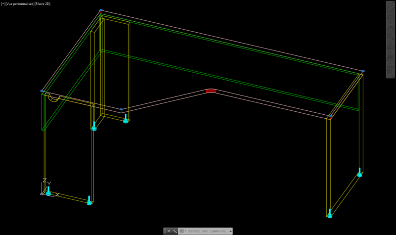
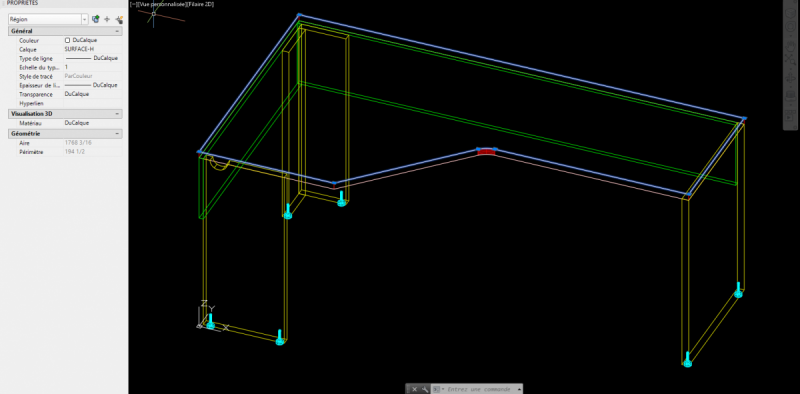
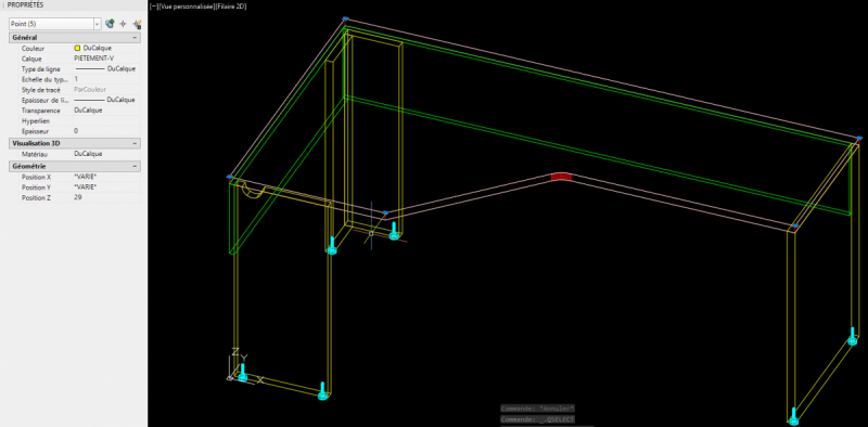
Hi, I have some desk drawing and I would like to add some "snap point" at the corner of my desk surface's. As they are in region, when I try using some lisp create by people who select polyline, line and all sort of line it don't work. I have about 20 500 drawing to make.*** I don't want my dwg to be in block because for the next step it won't work. Here is my dwg in witch i would like to ad point. 3-ML20366620LHRPMPM.dwg Thx
-

Need help with modifying pointsin.lsp by Tom Haws
shercer posted a topic in AutoLISP, Visual LISP & DCL
Hi, I'd like to modify this lisp to insert survey points as block showing only point number (2D or 3D, doesn't matter), and I'm having trouble figuring it out. Point file is in format: "Point number","East","North","Elevation" I'm attaching ex. files. I'd be thankful for any help. Points.txt pointsin.lsp point.dwg- 7 replies
-
- point
- import coordinate
-
(and 1 more)
Tagged with:
-
Find the highest and lowest mark from the selected "points"
sathalex posted a topic in AutoLISP, Visual LISP & DCL
Hello! In my drawing there are 200 primitives "point", how would I quickly find the highest and the lowest of them? -
accessing entity in a codes windows selection set
maerfl posted a topic in AutoLISP, Visual LISP & DCL
Hello I'm not able to figure out how to easily access the first entity of a slection set created with coded windows selection. I want to read out coodinates of the first point of 2 different objects which are "grabed" in a coded windows selection set. One polyline, one line. Then I want to copy the line from it's first point as basepoint to the first point of the polyline. Advanced I would like to copy it to all the other points of the polyline too. So it would be further more interesting to know how to access (read out the coordinates of) the second, the third and so on point of an object...using visual lisp. The following code is using first a pick up of the object where the line should be copied to and a static coordinate for the basepoint of the line instead of a read out coodinate: (vl-load-com) (setq sel1 (ssget "_w" '(-2 -2) '(115 10))) (setq e (car (entsel))) (setq topoint (vlax-curve-getStartPoint e)) (command "_.COPY" sel1 "" "0,0" topoint)- 2 replies
-
- selection set
- point
-
(and 3 more)
Tagged with:
-
Working Point Lisp, skips a line and I can't figure out why
jesset posted a topic in AutoLISP, Visual LISP & DCL
Hello, I have more or less completed this little lisp and I can't figure out why it is skipping the first line after my 'if' statement. Basically, when you're in paperspace, it'll put your cursor into modelspace and you pick the point you want to annotate with a working point. For some reason my lisp won't go into modelspace. ;; This lisp creates a working point leader in paperspace ;; known bugs: the current selected multileader type will be the style of the working point ;; Rev 1 2017-03-02 ;; Created by J. Therrien (defun c:WorkingPoint (/ WorkingPoint Easting Northing Point PSPACEPOINT PSPACE TEXT TEXTPROPS COORD NorthingWP EastingWp) (if (and (= (getvar "TILEMODE") 0) (= (getvar "CVPORT") 1)) (;;then (command "_.mspace" );;end command (setq WorkingPoint (getpoint "\nWhere is Working Point?: ")) (setq Northing (rtos (cadr WorkingPoint) 2 1));;set "y" value of WorkingPoint to Northing (setq Easting (rtos (car WorkingPoint) 2 1));;set "x" value of WorkingPoint to Easting (setq NorthingWP (strcat "N: " Northing));; creates the proper formatting for the leader (setq EastingWP (strcat "E: " Easting));; creates the proper formatting for the leader (command "_.point" WorkingPoint);;end command (setq point (entlast));;set the workingpoint to point (command "_.chspace" point "" "");;this brings the workingpoint set in the modelspace to paperspace (setq pspacepoint (entget point));;get the properties for point (setq pspace (cdr (assoc 10 pspacepoint)));;find the x&y coords and set to pspace (setq anotbp (getpoint "\nSpecify leader basepoint: ")) (COMMAND "mTEXT" PSPACE "@30,-30" "WORKING POINT" NORTHINGWP EASTINGWP "" );;end command (setq text (entlast));;set mtext to variable text (setq textprops (entget text));;get the properties from text (setq coord (cdr (assoc 1 textprops)));;find the string properties and set to coord (command "_.mleader" pspace anotbp coord "_.erase" point text "" );;END COMMAND );;end then (alert "Make sure you are in paperspace to use this command");;else );;end if );;end defun -
Wish To Snap While Running Polyline Command
"Mitch" posted a topic in AutoCAD 2D Drafting, Object Properties & Interface
While running in Line command I'm able to snap along the way, snap my running line to itself at each sub prompt: "Specify next point or..." When I try this with the Polyline command, while running polyline at each sub prompt: "Specify next point or..." no snap can be acknowledged. My Polyline won't snap to itself while running toward successive points. All Object Snaps are checked in it's dialog box. Alignment Point Acquisition is set to Automatic. Is there another setting or a system variable that needs to be toggled, maybe something related specifically to Polylines? -
Hi, I want to make a script who draw circles in multiple Points. The Points are automaticly made in a extension to autocad. All the Points are in same layers. It´s around 200 to 1000 Points in the drawing. My first issue is to find a commando who draw circles, with basepoints in all Points. Does anyone know the appropriate command for me? Regards, Emil
-
Hi! I have a drawing with mixed points and blocks. Area is huge and I really can't work. I have an idea to replace all the blocks with points, hope it will reduce a bit size of the drawing. Could you help me with that? Uncle Google couldn't help me with it unfortunately... Simply - have to replace large ammount of blocks (two lines crossed with level in the central point) with points. Many thanks!
-
Need a lisp to LIST all selected point coordinate at once
Sooshiant posted a topic in AutoLISP, Visual LISP & DCL
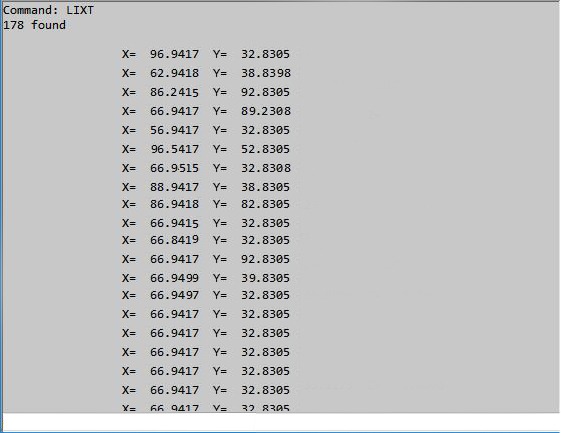
When you select some points and type list, AutoCad brings a list of some data such as point coordinate and layer name or color etc. On the other hand if you have a large number of points you need to press enter and go to next page. One year ago I saw a lisp routine which could list all point coordinates in list window without any further unnecessary data, so you could copy and paste all your selected point coordinates to a text file or excel at once. Now I have lost that great lisp. That was something like this pic (this has created by Photoshop) If anyone have it please give it to me or please write a lisp like this for me again. Any help would be greatly appreciated.- 6 replies
-
- list
- coordinate
-
(and 1 more)
Tagged with:
-
I have a cube that I need to fillet but the fillets must merge. the left to centre edge/fillet is a constant curve. the same with the bottom to centre edge/fillet. but the edge from centre to the right starts at a radius and goes into a point at the corner. What command or sequence of commands can create this? Note, the point where the 3 fillets meet must all curve gently.
-
Hello, I cannot find the default settings that control the point label style for a surface. I start a new drawing with no template, import an xml surface, turn on some contours and the points. I cannot find where that sneaky elevation style is hidden in order to change it. All help is greatly appreciated. Regards, phil
-
Hi everybody, this is my first post. I need a Lisp to generate a polyline from existing points. The polyline should be created from all the points at the edge of the cloud of points generated by a 3d scanner. The points are in 3 dimensions, but they could be flatted to zero. The polyline can be close or open: it does not matter. Any idea? Thank you folks in advance. dave:acad:
-
I m trying to make a selection set using a point and a couple of lines passing through this point (caution, NOT terminating). I want to select lines of specific layers. What I m typing is this (setq pt (getpoint "\nSelect point: ")) (setq ss (ssget pt '((0 . "LINE") (8 . "mylayer")))) Unfortunately this doesn't work. The only way I could find is to use this instead (ssget "C" pt pt '((0 . "LINE") (8 . "mylayer"))) However I do not find that helpful at all. If there is a line at the back on an other elevation, not crossing the initial line, but coincidentally passing 'visually' through this point (pt) the later ssget command will include both and that is not what I want. How could I use a point and filter together? Any help would be appreciated.
- 5 replies
-
- selection set
- point
-
(and 3 more)
Tagged with:
-
Hey guys, I'm trying to make a lisp where the user would pick a point in the model and the lisp would create a multileader in paperspace with the coordinates pulled from the model. Here's the code I got so far: (defun c:test (/ WorkingPoint Easting Northing Point) (command "_.mspace" );;end command (setq WorkingPoint (getpoint "\nWhere is Working Point?: ")) (setq Northing (cadr WorkingPoint));;set "y" value of WorkingPoint to Northing (setq Easting (car WorkingPoint));;set "x" value of WorkingPoint to Easting (command "_.point" WorkingPoint );;end command (setq point (entlast));;set the workingpoint to point (command "_.chspace" point "" "" );;end command (setq pspaceworkingpoint (entget point)) (setq mleaderinspt (list (car pspaceworkingpoint)(cadr pspaceworkingpoint))) (princ mleadinspt) );;end defun Whenever I run this, for the "mleaderinspt" variable I get nilnil What I want to do is create the multileader insert point where the user picked the original working point but I'm having a hard time translating that to the paperspace. Please note I haven't added error checking yet as this is still in the developmental phase/proof of concept. Any and all help is appreciated. Thanks! EDIT: Think I figured it out, I'll update this thread if it works.
- 5 replies
-
- point
- multileader
-
(and 2 more)
Tagged with:
-
Hello there, I'm using Auto CAD 2013. When i draft on large drawings with a lot of objects sometimes is hard for me to pick/track points automatically. I'm wondering if it's possible to shift between AUTOMATIC and MANUAL point acquisition while drawing without entering options (temporary disable automatic acquisition)? is there a shortcut? Thank you in advance...
-
In http://www.cadtutor.net/forum/showth...8-Inventor-101 I am at posting 33 and I came to a halt. I can't draw a point on the flat, and I don't see any midpoint on the created line. What do I have wrong? Table.ipt
-
Picking a station along a curve - AutoCAD
stiebert posted a topic in AutoCAD 2D Drafting, Object Properties & Interface
I have a paper plan set of a sidewalk that contains several simple horizontal curves. I've managed to use the curve data to replicate the sidewalk centerline in my CAD file. The outside edge of the sidewalk is kind of a zig-zag polygon line. To locate change of direction corners in the zig-zag line I was given the location point as a station along the trail and offset distance from trail centerline. My question is how do I easily locate a point along the curve at a specified station. I've managed to do a few using the MEASURE command and I insert a block at the specified station as a distance from the point of curvature. This works, but is very cumbersome and on top of that every time I insert the block it inserts 4 of them at the specified length that I entered. Please let me know if anyone has a quicker method. Also, if you know how to fix my problem with the MEASURE command I would appreciate that as well. Thanks, -

snap polyline to a point
GISdude posted a topic in AutoCAD 2D Drafting, Object Properties & Interface
Hi all, I used the measure command to place points along a polyline. I'd like to draw a poly from the points that were created. I can't seem to snap to those points. I don't see anywhere to get the osnaps to snap. Any ideas? I''ve googled and no luck. Thx, -
I am looking for a way to import my regular p,n,e,z,d text files with a custom tag for the point number. For example when I collect OG shots I like to number them OG##(
-
Hello, How we cad find two match point in a point2dcollection? The following code does not work correctly. Point2dCollection colPt = new Point2dCollection(); string sDoubleVertex =""; for (int nCnt1 = 0; nCnt1 { for (int nCnt2 = 0; nCnt2 { // Step to the next iteration. if (nCnt1 == nCnt2) continue; if ((colPt[nCnt1].X.ToString() == colPt[nCnt2].X.ToString()) && (colPt[nCnt2].Y.ToString() == colPt[nCnt2].Y.ToString())) { sDoubleVertex = nCnt2.ToString() + "," + sDoubleVertex; } } } Thank you, Mohsen
- 2 replies
-
- point2dcollection
- point
-
(and 1 more)
Tagged with:
-
I can't figure out how to choose my starting point to be relative to another point without drawing help lines (which mean they must be drawn, selected, deleted = time). I am certain there must be a way around this. For argument's sake, consider I am attempting to draw a cross. I use the line command, input a starting point; choose next point: @100 Now I need a vertical line of equal length to cross the middle-point of the horizontal one. I could snap to middle-point, draw a line of half-length at angle 90 and draw another of 2.(length) at angle -90. This produces 2 lines one of which is unwanted must therefore be selected and deleted. This simple example illustrates my point. I need a command which allows me to choose my first point (for the LINE command) as the point which is "X" units at angle "alpha" relative to a point "x,y" (or a coordinate selected by the SNAP tool if you will). Please take into consideration that the solution must be able to satisfy the stated problem and not the chosen example only. I thank anyone's input in this! Now I gotta put my thinking cap on again...
-
Getting Coordinates of a polyline with a constant X step
Steven29410 posted a topic in AutoCAD General
Hello everyone, in order to obtain a seabed profile for a school project, I need to get the Y coordinate of a polyline on several Kilometers with a fxed X step of 2m between each point. For the moment, the only manual solution I have found is to create a vertical line every 2m and to get the distance between the intersection of this line with my polyline and an horizontal line representing the mean sea level. Is there any way to automatize it because it is very long to do manually and I don't have enough time ? I did not succeed in doing this with dataExtraction. I also found on the internet a LISP file which extract the coordinates of points contained in the window. Nevertheless, I was told it is not possible to create automatically points on a curved polyline with a fixed x step. What I need at the end is an excel file of this type to use it in another software: X(m) Water Depth (m) 0 15.121 2 15.134 4 15.147 ... ... I precise I am a beginner in autocad, I have started today. Have you got any idea to solve this problem ? Thank you in advance

