Search the Community
Showing results for tags 'map'.
Found 7 results
-
I am making a free topo tool that makes use of Mapsui maps ( https://github.com/Mapsui/Mapsui ) that reads and manipulates shape and KMZ files and then inserts them in model space already projected. The problem is that it doesn't show the map inside the window, I don't know if I have to do it a...
-
Hello, I have a city map with lots of building plans, most of them are 3D polylines and all of them has different Z values, according to their heights. I want to make a 3D model out of it by simply extruding them. But those 3D polylines have vertexes on different elevations. Is there a way to find a...
-
Hello, I am trying to find a way to view the geolocation map as grayscale within the active drawing. Can anyone assist? Thanks, Phil
-

How to create various scale output of a given image file
coralflame posted a topic in AutoCAD Drawing Management & Output
Hi! I have a 1:50000 jpeg image of a sample map and I wanted to create output images of 1:25000, 1:12500, 1:10000 and 1:5000. How can I do that without sacrificing the quality of the original file? Thank you in advance. -
Newbie here with a question. I have just begun to explore autocad 3d 2008. I have been through the tutorials and have watched everything on you tube I could find. Therefore, I barely know anything about autocad. My question is, can I upload a map of the county/parish I live in then draw its boun...
-
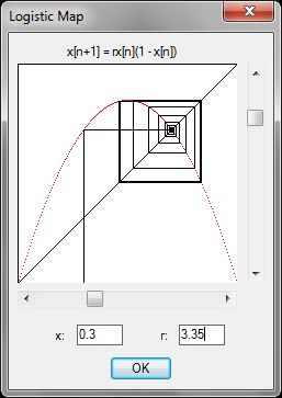
As many of you will know, I am currently studying for a degree in Mathematics, and, as part of the course, we study the dynamics of such functions as the Logistic Map. I've always been fascinated by this ostensibly simple map, which produces astoundingly complex dynamics resulting in chaos if a...

-

Creating a surface or solid from a Contour Map?
Sian posted a topic in AutoCAD 3D Modelling & Rendering
Hi, I have a contour map in polylines in the correct elevation and I was wondering how I can make it into a surface? I have read many threads and searched the AutoCAD Architecture 2010 user documentation but cannot find a "drape" command which everyone seems to suggest from other peoples posts....