Search the Community
Showing results for tags 'civil 3d'.
-
One of our most tedious and common tasks is labeling swales. You draw a polyline, you add a few elevation markers based on the design surface, and that's about it. So it would be nice if we could write a program for that. Plus it would be nice if it's easy to maintain. According to my re...
-

Creating a surface model in Civil 3D from existing 3D polylines, lines and points
0misclose posted a topic in Civil 3D & LDD
Hi all, I'm quite new to Civil 3D and I've tried to have a look online to find what I'm looking for but I feel it might be easier to just ask. I'm wanting to generate a surface model of a complex feature survey which I currently have in AutoCad. All the 3D linework for kerbs,... -
We often have ditches in roadway cross sections. I create a feature line to model the bottom of the ditch, so that there's a target for the slope into the ditch. My question is, is there any way to specify a point by providing a station and an offset off the road alignment, so that I can place the f...
-
Hello, I have users that are running 2018 without issue and the same users also have 2021. Geolocation works fine with 2018 but with 2021 their 360 login name is present but geolocation will not load maps. Opening the same file in 2018 works fine. The other item is when the pull-down is...
-
Hello all. Got a bit of an odd one. Just got a new laptop with Civil 2021 (version 2021.2) Everything works as expected until I try and open a drawing with previously created Pipes using Pipe Networks. Once I open the drawing I can see everything but it always just hangs and Civil s...
-

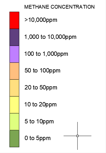
AutoCAD Civils not showing enough minimum and maximum ranges
Nellie posted a topic in Civil 3D & LDD
Hi, This problem keeps popping up for me, not every time but I really want to understand why the error happens. I am using AutoDesk Civil's 2020 and trying to create a heatmap from data picked up on site by a GPS gas reader, the data needs to be shown in 8 ranges of set readi...
-

civil 3d Is there a lisp routine to move text to block base point?
CADman123 posted a topic in AutoLISP, Visual LISP & DCL
I want to move text to the nearest block intersection point so i can build 3d models from text. Without this my text is not bang on the marker. -
Ever since installing the 2019 version of Civil 3D, my command window will not stay docked. I am asking for help at this point because I do not know what else to do and have scoured the web in search of answers and have tried just about everything I can think of. Before all the usual suggestions com...
-
 my co-workers say always go with overlay and they tried explaining to me but I couldn't understand.
 -
I want to ask you guys what your process is for checking your completed markups? I check my drawings once or twice to see if I picked up everything but it irritates me that when I send it to the engineer I always miss something tiny or something that wasn't marked up at all and I probably should hav...
-
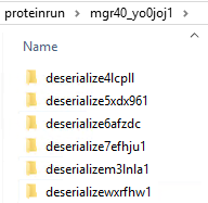
I'm not sure if this is limited to Civil 3D, or whether it applies to AutoCAD also. I'm starting to find that inside of user's %temp% folder, is a subfolder named "proteinrun", and inside this folder are tons of other folders, and inside each one of those, are more files and folders. On the few...
-

How do I change the colour of my surface so it stands out from the exisitng topo
juicyorange posted a topic in Civil 3D & LDD
I am looking to add clarity to my models for my clients and one thing I think would help that would be to add colour to the models I have. Mainly I wanted the design to have some kind of bright colour and the existing topo to be a darker colour. Any insights into this would be greatly appreciate... -
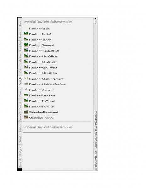
Hello, I am having trouble with the text size of the toolpalettes. All other items are just fine. If you have any suggestions it would be greatly appreciated. I am running 2016 and 2018, 2018 looks great, 2016 looks like the image below Regards, Phil
-
Hello, I have about 28 years of autocad experience, the last 10 being almost exclusively civil 3d. I am interested in adding revit to my skill set. Does anyone have a recommendation for tutorials? I know it took s bit of time to tackle c3d and I'm wondering what it will take to really get a hand...
-
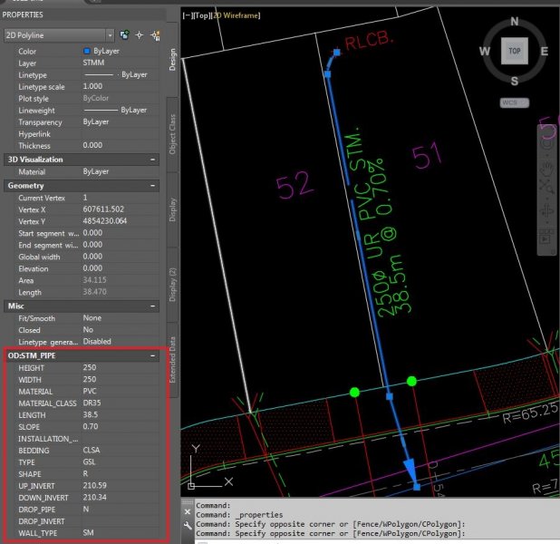
I need to add pipe properties to a 2D Polyline in AutoCAD or Civil 3D but I am not sure how to go about it. I have uploaded a sample file, the information I need to associate with the polyline is in the red box. If someone has any idea about adding these features to a 2D polyline please do let me kn...
-
Using Civil 3D 2016 and having Intermittent Problems with not being able to remove items from the selection set. Anyone else having this problem? Terry Nolan www.FloridaDraftingServices.com www.1stProto.com 1stProto Design Services
-
I am working on a project that has dirtwork everyday that i need to run cut and fill quantities from daily asbuilts. Currently we are using Topcon Magnet Office DTM model (triangles), I am wondering if it will be more practical or accurate to use a Civil 3d surface to run these daily updates.
-
Hello All, Does anyone else have an issue with the command LAYUNISO? Every now and then when using this helpful command after using LAYISO it says that "Layers isolate by LAYISO command have been restored" but that is not always the case. Sometimes the layers are not restored and are left in a f...
-
Hello, I need to specify the slope of the streets of a city. I have the elevation points of streets. But, how can I get slopes in Civil 3D? I am working with Civil 3D, but I do not know the procedure for this work. I should create a surface from these points? The surface's triangles must be...
-
I am receiving error message "surfaces do not overlap" when i try to get volume between two surfaces.. i have two surfaces: 1. Made up of Survey points 2. Polyline which i put an elevation to make it 3d poly and then convert it into block before making it a surface. What could have I done wron...
-
When using the Intersection Wizard in Civil 3D (2013) I get holes (spaces of non-filled in areas) in the intersection corridors that make up the intersection corridor. Why and how do I fix them?
-
Hi everyone, this is first time that I am posting on this forum, and I hope that I will get help. I am using Civil 3D 2014, and a couple days ago I changed my ATI HD 4850 with Nvidia GTX 570 2.5GB. And I did not noticed any improvement with new card! My road is about 5 km long, I have about 3000 po...
-
Hello People. Yesterday i downloaded AutoCAD CIVIL 3D 2015 in my Dell with windows 8. I was currently working with civil 3d 2013 and I appeared errors shareability with windows 8. A result of that I decided to download and install civil 3d 2015 by the shareability of windows 8. But when you st...
-

import dng to dwg, cannot see all data in autoCAD.
faveo posted a topic in AutoCAD 3D Modelling & Rendering
Hi I am using autocad civil 3d 2010. I got .dng files (in 3d) from a customer. I was able to import the data to .dwg (no problem). However, some data seemed to be missing. The customer could see all data in microstation. He said I needed to change the display depth cause some z-number were -9999... -
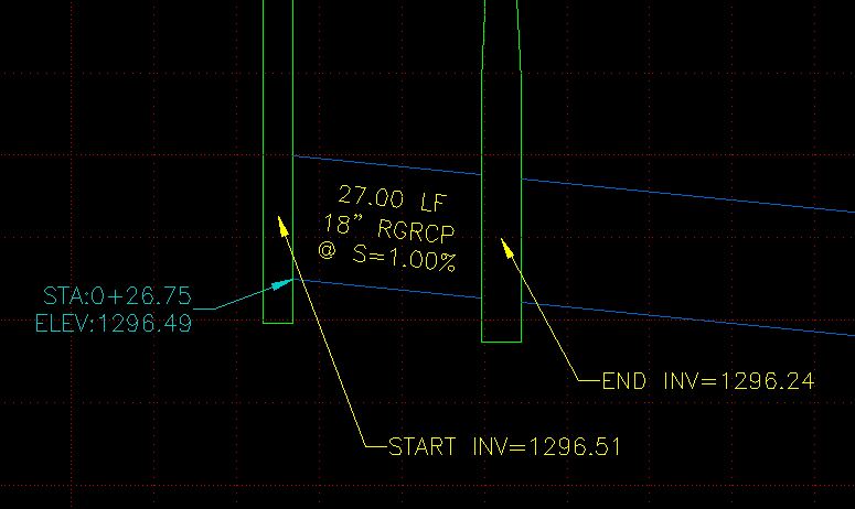
So I am profiling some storm drain pipe and would like to label it with accurate labels. What I mean is that right now I use a profile label (blue in the image) to reflect the correct invert elevation at the edge of the manhole. I would like to use part labels so that as I modify the pipe the labe...