Leaderboard

Popular Content
Showing content with the highest reputation on 02/22/2022 in all areas
-
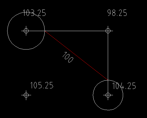
No, you need to draw say a line between the points eg 103.25 90.45 so if 50' then 3.25/12.8 * 50 = 12.695 so draw a circle on the 103.25 of rad 12.695 where it crosses the line is contour point 100. Go to next grid and keep going its going to take a while, its a case of join the dots.2 points
-
This is just so old fashioned question no one does contours manually any more that's like when I started Civil Engineering back in the 80's. Ok the answere is to do with ratios 103.25-90.45 = 12.8 103.25-100 = 3.25 so 3.25/12.8 * distance between the 2 points is the location of contour 100, its a repetive sequence very time consuming. 100-180 means look for point ranges 100-110 110-120 120-130 .......... Again why would a training exercise have something that is just so out of date. Thousands of points contoured in seconds. TIN software is out there free I would look at that.2 points
-
If one point has an elevation of 90.45 and the next has an elevation of 103.25 there would be a DE (difference in elevation) of 12.8 but to prorate the distance from the first point you need the distance between those points. You need to interpolate all the points that fall on those 10' contours horizontally, vertically & diagonally in order to sketch those contour lines correctly.2 points
-
If your first spot elevation is 92.2 and the second spot elevation is 113.3 then you will have a 100.0 foot and a 110.0 foot contour interval between the two points.1 point
-
If it helps, think of interpolation as a simple algebra problem. You know the X and Y values of two points. You can draw a line between those two points. Given another value of Y (the contour), where does it fall on that line? That's where your contour crosses the grid. I believe that's what ReMark was trying to explain in his first comment. To draw a contour, you have to find all the points where it crosses the grid and connect the dots. If you know how to draw a spline, that will help smooth out the kinks.1 point
-
Why would a training exercise have something that is just so out of date? Because it is a Penn-Foster AutoCAD project and the course teaches how to use AutoCAD not how to use TIN software.1 point
-
Hoping this helps straighten you out re: interpolation. (Project 6 - 562 Ocean Avenue) The mathematical interpolation of contours goes something like this. Let's say we have two spot elevations A & B. A = 32.7 and B = 54.0. The distance between A & B = 50 feet. We want to know where our 40 foot contour would fall between spot elevations A & B. First obtain the total elevation difference. This is done by subtracting A from B. 54.0 minus 32.7 = 21.3. Next we want the difference in elevation between our 40 ft. contour interval and the nearest spot elevation which in this case is A or 32.7. That works out to be 7.3. Now we need to calculate the distance (let's call this "d") we need to go from spot elevation A to our 40 foot contour. That takes the form of: d/7.3=50/21.3 or d=7.3*50/21.3 = 7.3*2.347 = 17.13 or the distance, in decimal feet, to our 40 foot contour. Make any sense to you?1 point
-
I have moved your thread to the Student Project Questions Forum.1 point
-
All it is asking you to do is create the contours 100, 110, 120, 130, 140, 150, 160, 170 and 180. Every 10' for just the contours between 100'-180' Anything above or below that is not required for this exercise1 point
-
tombu we did the same surveyed a park and designed a drain into the lake all by hand including plans. For Jonna
 1 point
 -
Here you go . (defun c:colorchange nil (vlax-for layer (vla-get-Layers (vla-get-ActiveDocument (vlax-get-Acad-Object)))(if (= 2 (vla-get-Color layer))(vla-put-Color layer 161))) (prin1) ) (vl-load-com)1 point