Leaderboard


Popular Content
Showing content with the highest reputation on 01/16/2022 in all areas
-
Version 1.7.0
3,597 downloads
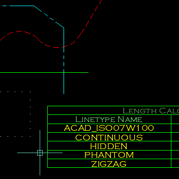
This program will calculate the total length of Lines/Polylines/LWPolylines/Arcs/Ellipses/Circles/Splines with an optional filter. The Filter may be used to select only those lines that are on a certain layer, or perhaps have a certain linetype or colour. The results of the calculation can be displayed in an ACAD Table within the drawing, or written to either a CSV or TXT File. The Table-Style may be selected from the drop-down in the main dialog. Main interface The main dialogue box allows the user to filter lines by layer, linetype or colour and select the table style. Multiple selected items can filtered. A filter string may be entered to help the user quickly find the filter items that he/she requires. Options The options dialogue box allows the user to specify which object types should be included and the type of output, table in the drawing, CSV file or TXT file. Demo Function Syntax: LenCal For instructions on how to run the program see here. Any comments, criticism and suggestions are welcome. Either PM me directly, or reply to the original thread.1 point -
Version 2.1.30
7,406 downloads
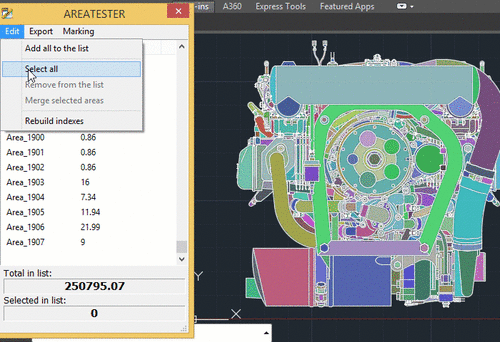
AreaTester is a efficient plug-in for AutoCAD. It allows you to quickly measure the area in AutoCAD and gives you advanced capabilities to process the results of the calculations in the further workflow (annotate the the areas in the drawing, convert the received data to different spreadsheet formats, etc.). The plugin calculates not only the areas of enclosed objects, such as a polyline or circle, but also any other shapes formed by the intersection and connection of various types of objects, which include lines, arcs, splines and many other AutoCAD basic objects. At the same time, to calculate the area of any enclosed shape, you only need to point the crosshair of the cursor on it and the area value will be instantly displayed in the context window above the cursor. In addition, the user can create the necessary list of the areas in the main application window for the further workflow. All these areas are summed automatically in the created list. The total result of the summation is displayed at the bottom of the main window of the app. One of the main features of AreaTester, compared to the standard AutoCAD tools, is the ability to determine the area value of any bounded shape excluding the areas formed by objects that have got inside such an shape (the so-called "islands"). This option significantly simplifies the user’s work on calculating areas in AutoCAD, eliminating the need for additional mathematical operations. Key features of the AreaTester for AutoCAD plugin: Automatic calculation of the all areas in a drawing. Annotating the areas directly in a drawing. Drawing boundaries of the shapes in the form of polylines. Exporting the generated list of areas to the clipboard or some convenient data format (* .txt, * .csv). Adding the table of the area list to a drawing. For more information visit the official website of the AreaTester app.1 point -
No, functions One & Two will only be defined when their respective defun expressions are evaluated, and such defun expressions will only be evaluated when the function Main is evaluated. When loading an AutoLISP file, the contents are merely evaluated as if they were pasted to the command line or console - the interpreter does not 'scan' for nested function definitions - in fact, the interpreter is entirely indifferent to the expressions being evaluated: you could happily load an AutoLISP file containing only princ expressions without defining any functions whatsoever.1 point
-
Another, for any depth of lists - (defun foo ( kys lst ) (defun bar ( kys lst ) (if lst (bar (apply 'append (mapcar '(lambda ( x ) (mapcar '(lambda ( y ) (list (car x) y)) (baz (cadr x) (car lst))) ) kys ) ) (cdr lst) ) kys ) ) (defun baz ( key lst / itm ) (if (setq itm (assoc key lst)) (cons (cadr itm) (baz key (cdr (member itm lst)))) ) ) (bar (mapcar 'list kys kys) lst) ) (setq list1 '(a b c) list2 '((a n1) (c n3) (b n2)) list3 '((n1 m1) (n1 m2) (n1 m3) (n2 m4) (n2 m5) (n3 m6)) list4 '((m1 p1) (m2 p2) (m3 p3) (m4 p4) (m5 p5) (m6 p6)) ) _$ (foo list1 (list list2 list3 list4)) ((A P1) (A P2) (A P3) (B P4) (B P5) (C P6))1 point
-
(setq List1 '(a b c) list2 '((a n1) (c n3) (b n2)) list3 '((n1 m1) (n1 m2) (n1 m3) (n2 m4) (n2 m5) (n3 m6)) list4 '((m1 p1) (m2 p2) (m3 p3) (m4 p4) (m5 p5) (m6 p6)) ) (mapcar '(lambda (x / y z) (cond ((setq y (cadr (assoc (car x) (mapcar 'reverse list3)))) (cond ((setq z (cadr (assoc y (mapcar 'reverse list2)))) (list z (cadr x)) ) ((list y (cadr x))) ) ) (x) ) ) list4 ) -->((A P1) (A P2) (A P3) (B P4) (B P5) (C P6))1 point
-
In response to your message we have reviewed the project instructions on your student portal and it appears that there is one section that does not display correctly. While a correction is being made I have attached a file which contains the "missing bullet" items showing the distances and bearings required for the last two subdivision boundaries. Please feel free to contact me if you have further questions and keep in mind you can always attach your actual .dwg drawing file in a message for review to make sure you are on the right track. Sincerely, Jon D. Instructor 4 main subdivision boundaries.pdf1 point
-
you`ve put good use of the lisp, dcl here.. great1 point
-
Awesome! It's a very useful app. I use it all the time when I calculate the area.1 point
-
Great solution! Suitable also for cadastral plans. Etc. The speed of work is particularly striking.1 point
-
Excellent utility that does exactly what it's supposed to do and with an intuitive user interface.1 point
-
Version 1.0.0
645 downloads
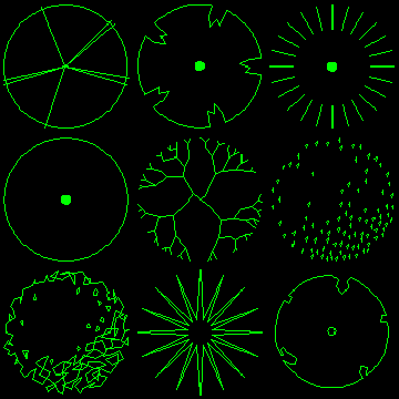
2D Tree Symbols (Collection 1) The plan tree symbols in this pack are compatible with AutoCAD Release 14 and higher. All drawings are relatively small (25-30KB) and are suitable for use as blocks within AutoCAD. They are ideally suited for Landscape Architecture planting plans. The trees have been drawn with a radius of 1 drawing unit. To insert a tree at the required size, simply enter the required radius as the insert scale factor. The trees are all drawn on layer 0, this means that they will adopt the characteristics of the current layer when they are inserted. It is advisable therefore, to create a new layer before insertion so that you can easily control object properties. In each case, the insert base point is in the centre of the canopy.1 point -
Version 1.0.0
2,499 downloads
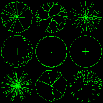
2D Tree Symbols (Collection 2) The plan tree symbols in this pack are compatible with AutoCAD Release 14 and higher. All drawings are relatively small (25-30KB) and are suitable for use as blocks within AutoCAD. They are ideally suited for Landscape Architecture planting plans. The trees have been drawn with a radius of 1 drawing unit. To insert a tree at the required size, simply enter the required radius as the insert scale factor. The trees are all drawn on layer 0, this means that they will adopt the characteristics of the current layer when they are inserted. It is advisable therefore, to create a new layer before insertion so that you can easily control object properties. In each case, the insert base point is in the centre of the canopy.1 point